 Loading... Please wait...
Popular Brands
Our Newsletter
 New Products
-
 $15,500.00
-
 $5,500.00
-
 $9,600.00
-
 $3,900.00
-
 $3,800.00
- Home
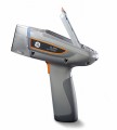
- XRF Analyzer
- USED DJI Zenmuse L1 Lidar Sensor
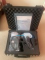
USED DJI Zenmuse L1 Lidar Sensor

Price:
$3,900.00
Brand:
Condition:
Used
Rating:
Availability:
In Stock
Shipping:
Calculated at checkout
Product Description
The DJI Zenmuse L1 is a cost-effective and easy-to-use industrial aerial LiDAR payload designed for DJI's flagship commercial drone, the M300 RTK. The L1 integrates a Livox sensor, a high-precision IMU, a one-inch 20MP CMOS visual camera with mechanical shutter, and a 3-axis stabilized gimbal system.
Combine with the M300 RTK and DJI Terra mapping software for a highly efficient all-in-one aerial LiDAR solution for acquiring 3D point clouds for high-accuracy and detailed reconstruction. The L1 can be used across a variety of industry verticals, such as energy, MEA, forestry, public safety, and many more.
Purchase includes:
– 1 gimbal and L1 camera set
– 1 64GB micro SD unit
– 1 lens cleaning cloth unit
– 1 storage case unit
– 1 DJI Terra Activation Code
– 1 year warranty from the time the item is received, with the following conditions:
> DJI: https://www.dji.com/id/service/policy
WRITE A REVIEW